|
|
Post by Admin on Dec 28, 2015 18:28:04 GMT -7
A Comprehensive Road Plan - a work in progress
A comprehensive road plan for Glastonbury started when we measured each platted road and totaled the mileage. For the first time in my memory we now have exact total mileage for paved and gravel roads in all three sections of Glastonbury; North Glastonbury(NG),South Glastonbury below Hercules(SG) and High South Glastonbury(HS); the area that is accessed via Hercules Road. Click on the below links to read more about Glastonbury platted roads.
"The Association intends to maintain a private road system within the platted road easements for vehicular access to the various parcels within the community. Initial construction by the developer(s) was intended to be a basic gravel and dirt consistency."GLA Covenants Section 8.01c.
I understand the above phrase taken from the GLA Covenants to mean that:
- The GLA intends to maintain a private road system to reach all parcels. Not just ones near the paved roads but ALL parcels.
- The road system is within the original platted road easements. The platted road easements contain ONLY the original roads that were included when Glastonbury was formed. It does NOT include any county roads such as Dry Creek, Storey Road, etc. Nor does it contain roads or long driveways developers created when they subdivided original parcels.
- The original construction was simply bulldozed earth covered with some gravel. Little attempt was made to create roads that met Park County standards as depicted below.

- The Park County Gravel Road standards call for a compacted sub-base layer of dirt, clay and rock. The compacted layer is crowned, about 60 feet wide and has two ditches; one on either side of the road. On top of the compacted base layer is placed nine inches of coarse angular rock. Each rock is about the size of a softball; what Park County calls "3 inches or minus(smaller)". A three inch top layer of "road mix" or small angular gravel, one inch or minus(smaller) mixed with clay is added. The "road mix" forms the uppermost layer and is what a grader normally smooths out, a truck sprinkler waters and a roller compacts. The clay component holds the gravel together and forms a somewhat impervious surface that water will normally flow off of. The "road mix" layer is the working surface of a well designed gravel road and must be replenished periodically. Sometimes manganese chloride is added to the road mix layer. Manganese chloride draws humidity from the air and helps to maintain a constant moisture level in the clay component of the road mix.
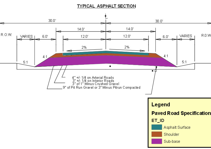
- The Park County Paved Road standards call for a compacted sub-base layer of dirt, clay and rock. The compacted layer is crowned, about 60 feet wide and has two ditches; one on either side of the road. This is shown in purple below. On top of the compacted base layer is placed nine inches of coarse angular rock. Each rock is about the size of a softball; what Park County calls "3 inches or minus(smaller)". This is called the shoulder and depicted as a brown layer below. The angular rock is non-compressible and provides a stable, dry surface for the asphalt to rest upon and adhere to. A three to four inch top layer of asphalt, 24 feet wide and crowned is applied over the nine inch shoulder layer of angular rock. Three inches is used on roads with light traffic while four inches is reserved for arterial or heavy traffic roads. This layer is colored blue-green below.
 What do we have for roads and do they meet or exceed Park County standards?
- None of Glastonbury's platted gravel or paved roads meet Park County standards with one notable exception. The last mile of Sagittarius Skyway in High South was privately developed and paid for. It meets Park County Gravel Road standards. The rest of Glastonbury's platted gravel roads were never designed to meet County standards. They lack the nine inch layer of angular rock noted above. Many gravel roads are simply compacted dirt and rock with a one to three inch layer of "road mix" on top. Over time the gravel is pounded into the dirt below and the road surface is compromised. Careless grading can also mix the dirt with the gravel and ruin the road surface. Wash boarding is a serious problem and more prevalent when the road lacks a stable, angular rock base.
- Many High South roads lack not only the nine inch angular rock base layer but also lack even a sprinkling of gravel. They are worn down to bedrock in many places and often slope dangerously towards roadside cliffs or sharp drop offs. Many miles of High South roads have clogged drainage ditches which result in washed over and severally eroded road surfaces.
- Almost all Glastonbury gravel roads have cobbles that are frost heaved to the surface every spring. A nine inch angular layer of rock would prevent frost heaving while providing a dry and stable surface for the road mix gravel to rest upon. The angular rock layer also prevents the road mix from getting mixed with the dirt base layer by grading or heavy traffic over wet roads. Once the nine inch angular rock is laid down only the road mix layer needs to be maintained and occasionally replenished.
- The only Glastonbury platted roads that are paved are located in North Glastonbury. They consist of just two inches of asphalt placed directly on a compacted dirt and gravel base. There is no shoulder layer of angular rock to drain away moisture and provide a stable, dry base for the asphalt. Some ditches exist but they are not extant over the entire 3.2 miles of paved road. Over the years the paved roads in NG have cost over $170,000.00 to maintain.
- South Glastonbury uses a county paved road, Dry Creek, for access. Although Glastonbury landowners paid for the asphalt the County pays to maintain the road. Dry Creek is NOT part of the Glastonbury platted road system.
Now we know what we have for roads and what the Park County standards are. The next installments in the Comprehensive Road Plan will be to study what we have for funding in 2016 and then objectively list the conditions of each platted road in 1/10th mile sections. We will also talk about washboarding in detail. Your comments and criticisms are appreciated and may be posted below. |
|
|
|
Post by Admin on Jan 24, 2016 14:06:01 GMT -7
A Comprehensive Road Plan - Glastonbury Road Problems
From the above post and two previous to it we know:- The exact mileage of all GLA platted roads in North and South Glastonbury.
- The Park County Standards for roads as shown above.
- That only one mile of Glastonbury platted roads, a privately developed section of Sagittarius Skyway, has a base that conforms to Park County standards.
Glastonbury roads have many problems. The gravel roads are often heavily wash-boarded, eroded and full of jagged rocks and cobbles. The paved road loop in North Glastonbury requires extensive crack sealing almost on a yearly basis that has cost $170,000.00 in maintenance since 2009. Eventually the NG loop will need to be completely rebuilt at a substantial cost to landowners. One of my goals in writing these posts is to define the road problems and offer several solutions.Gravel Road Problems The major problem with Glastonbury gravel roads is wash-boarding; a series of ripples that create a surface that looks like an old fashioned washboard.  Below is a photo of a wash-board on Hercules Road in South Glastonbury.  This stretch of Hercules has several problems that are typical of all Glastonbury gravel roads. It is wet and has poor drainage. Water has washed across this road and severally eroded the right edge. The left side drainage ditch is clogged and does not receive routine maintenance. The road surface is moist, heavily rippled and partially damaged by vehicle tires digging into the soft, absorbent clay. Hercules, like almost all Glastonbury roads, does not have a 9 inch layer of angular rock covered by three inches of road mix gravel. It also lacks proper drainage ditches and does not receive thoughtful regular maintenance. Hercules is a main arterial road and should be rebuilt to Park County standards at least as far as Spectec which is where the majority of the traffic originates. If Hercules and many other Glastonbury gravel roads had a 9 inch angular rock base and proper drainage ditches then the road surface would be drier and less susceptible to wash-overs, water erosion, tire digging and wash-boarding. Wash-Boarding
Traditionally wash-boarding was thought to be caused by vehicle tires slipping, scuffing and digging up the gravel road surface. It was recommended that people use four wheel drive and travel slowly to increase traction, reduce scuffing and tire digging. A University of Toronto paper shed new details on road wash-boarding. They maintain that ripples are caused anytime a wheel is rolled over any malleable surface. Think of wind blowing over the surface of a still lake or pond. The same ripples form when vehicles roll over moist Glastonbury roads. The Toronto study also concluded that ripples will form even in loose, dry sand and at speeds just above 3 miles per hour. The above photo shows a series of waves or ripples in the jello-like road surface. Note how the tire scuffing is at the tops of the waves and not the base. Over time the ripples flow, change shape and height as moisture and/or traffic increases.
On a County Standard road some moisture is needed to hold the 3 inch clay and gravel "road mix" layer together. Too little moisture and the layer will turn to summer dust and wash-board. Too much moisture and the mixture will change to soft, pliable jello and wash-board. Magnesium Chloride is often graded into the topmost 3 inch layer of a gravel road. Magnesium Chloride attracts moisture from the air like the silica gel packets you often see with new electronic items. It helps to maintain the "just right" moisture level during dry summer months. Dust and washboards are reduced and the road surface is strengthened. Magnesium Chloride does not harden like concrete so routine grading is not affected. On overly wet roads magnesium chloride can mix with the mud, adhere to car surfaces and cause metal corrosion.
Wash-boards also form in snow, sand and even on railroad track rails. On Glastonbury roads which lack a nine inch angular base, the ripples can go 12 inches or more into the road's subsurface of clay and cobbles. Thus wash-boards often show up a week or two after grading. Grading only smooths over the top two inches or so of the rippled clay and cobbles. The ripples below remain and traffic over moist roads quickly brings them to the surface. Nine inches of angular rock would permanently separate the clay and cobble subsurface from the traffic bearing surface. Rain and snow melt would drain away more quickly and with proper ditches, wash-over erosion could be eliminated.
Frost Heaves
Since most Glastonbury gravel roads lack a nine inch base of angular rock, frost heaves are common as depicted in the photo below.

Cobbles and often times sharp, jagged rocks are propelled to the road surface every spring. The cobbles are slippery to drive on. Jagged rocks excessively wear tires. On average High South residents only get 25,000 miles to tires that would easily last twice as long if used on better roads. Large cobbles damage snow plow blades and knock the shoes out from under plows.
Nine inches of angular rock would form an almost impenetrable surface for cobbles to pass through. A proper base would also drain away excess moisture and form a non-compressible platform to put the topmost, traffic bearing 3 inch layer of road mix, on. Grading would only smooth the top 2 to 3 inches of road mix; thus wash-boards could be completely eliminated in every grading operation.Paved Road Problems
The only platted Glastonbury road that is paved is the North Glastonbury loop. It suffers from many of the same problems as our gravel roads. It lacks a proper base consisting of nine inches of angular rock. Ditches are not maintained and even non-existent along parts of the paved road. Thus the base or subsurface of the paved road is often wet and jello like. The excessive moisture causes the relatively rigid asphalt road surface to buckle and crack throughout the winter and spring. Heavy traffic presses down on the weakly supported asphalt and creates alligator cracks which soon turn into pot holes. The pot holes allow moisture to accumulate which further weakens and undermines the road sub-surface.

Note how recent heavy truck traffic has left a tire tread mark in the gravel and upon entering the NG paved road caused the asphalt to crack. We circled the crack with orange paint so you could see it more clearly. Note also how the NG pavement has waves, basically large ripples that cause the asphalt to rise and fall across the width of the road. The subsurface was soaking wet and deformed with every vehicle that traveled over the road.

The Glastonbury Landowners for Positive Change sponsored a road walk on September 18th, 2015. We inspected the road, photographed it and discussed problems. Board member Charlene Murphy participated but was camera shy. Note how drainage ditches are absent from this stretch of paved road.

A tremendous amount of money has been spent crack sealing NG paved roads. The above photo shows the failure of a crack seal that is less than a year old. The tar never seeped very far into the surface and did not bond well with the asphalt. Dirt and small pebbles have been forced up into the original crack by a semi-fluid road base, frost heaves and heavy traffic which resulted in pushing the sealing tar away from the asphalt.
If the North Glastonbury paved loop road had been built to Park County standards many of the current problems and astronomical expenditures could have been avoided. The paved road lacks a 9 inch base of angular rock; the two inches of asphalt sit directly on top of clay and cobbles. Ditches are often non-existent and when present are not adequately maintained. The road subsurface is often wet and jello like. Crack sealing only addresses the problem of water flowing into cracks; it is not a solution to a wet and pliable road base. Crack sealing is expensive and often short lived. Eventually the road will need to be properly rebuilt as either a gravel or County Standard paved road.
In future posts I will deal with both scenarios and their respective costs.
|
|
chris
Full Member

Posts: 175
|
Post by chris on Jan 24, 2016 16:33:05 GMT -7
Excellent series of posts, Admin. Now if we landowners could only convince the GLA board to listen and act on your thorough research we might start making progress in the right direction. What are the odds of that happening?
|
|
|
|
Post by dorothykeeler on Jan 24, 2016 22:05:05 GMT -7
Thank you, Admin.!!!
Excellent photos, diagrams, and detailed explanations.
Folks, I believe that the GLA currently has NO INSURANCE.(Someone please correct me if I am wrong.)
If someone runs, slides, or is forced off one of our roads by another out-of-control driver and sues the GLA, then each and every landowner can be personally liable.
The "Homestead Act" may not protect you. If the value of your home and land exceeds $250,000, then a judge can just "subdivide" your property for you and call for your "excess" land to be sold.
There should be no money allocated to "Community Property" committee until the roads are fixed.
In fact, the "Community Property" committee should be dissolved for lack of available funds.
|
|
|
|
Post by Admin on Feb 6, 2016 12:36:48 GMT -7
Glastonbury has a Private Road System What does that mean? Comprehensive Road Plan Review:- We know how many miles of platted gravel and paved roads that the GLA is responsible for maintaining.
- We understand what Park County Standards are for paved and gravel roads.
- We understand some of the problems our roads have and what causes those problems.
If you understand the above points then we can move on to the next topic; A Private Road System.
The Covenants, section 8-C state "The Association intends to maintain a private road system within the platted road easements for vehicular access to the various parcels within the community.". Here is an aerial photo with a superimposed parcel map taken above North Glastonbury by the Soccer Field. Roads are shown as white lines and are named. Property boundaries are shown as yellow lines.
When Glastonbury was founded a road system was designed with the intent of connecting the various parcels. The roads generally followed parcel property lines but often were entirely within one or more edges of a parcel. All of the land was privately owned by Church Universal and Triumphant when the road system was created. Thus the network of roads was a private road system. Think of it like a really long driveway on a very large piece of land owned by the Church.
The original settlers of Glastonbury leased land from the Church and paid $240.00 per year per parcel for road maintenance. The Church still retained ownership and Glastonbury was 100% owned by the Church. The road system was used by Park Electric and Qwest to bury electric and phone cables to provide services to most parcels. Both companies required easements so they could legally access their cables and maintain them. An easement is a legal term that allows a company or an individual ACCESS to a piece of property that is privately owned. The Church still owned the property that the roads were on but now Park Electric and Qwest had a legal right to visit that property, dig up cables, install new ones, make repairs, etc. Around 1997 the Church, Glastonbury residents and El Moyra decided that the land should become private according to a September 27th, 1997 Bozeman Daily Chronicle article.
The Church established the Glastonbury Landowner's Association and started to sell parcels within the community. The road system still remained private. Now the property that the roads were originally built upon was owned by many individuals and not just the Church. The easement according to the GLA Covenants now allowed all GLA landowners to use the road system. Put another way, the Covenants gave a legal right to every GLA landowner to travel over the private road system. It is important to understand that the roads still ran over private property. In fact they ran over many pieces of private property that were owned by many individuals.
The roads do NOT belong to the GLA, to Park Electric or Qwest. But all three corporations have an easement and thus their employees or in the case of the GLA, members, are legally allowed ACCESS to the private road system. Conversely the general public is NOT allowed to use the private road system except as guests of landowners. Practically speaking anyone can drive over our private roads because we do not have them gated. Generally there is little reason for the public to use our roads because they are not a shortcut nor a path to a destination outside of our community. The only problems I am aware of with the public using our private road system is when hunters travel to High South and sometimes misbehave.
In the next installment we will post several Visions for Glastonbury Roads.
|
|
|
|
Post by Admin on Feb 6, 2016 15:02:13 GMT -7
Visions for Glastonbury Roads
The Glastonbury private road system is primarily designed to provide landowners with vehicular access to their parcel(s). It consists of primary or main roads that feed into secondary and tertiary roads. Primary roads tend to get the most traffic and tertiary the least.
The more traffic a gravel road experiences the more maintenance it will need. The reverse is also true; a gravel road that is lightly used will require only minimal maintenance. All roads deserve equal treatment to bring them up to a certain standard.
For the record: I consider North Glastonbury paved roads as primary roads. All other North Glastonbury platted roads I see as secondary roads.
I see Arcturus Drive and Hercules to the junction of Scorpio and Polaris as South Glastonbury primary roads. All other SG platted roads I am classifying as secondary roads.
I am classifying as tertiary roads all sub-division roads in North and South Glastonbury. These roads are NOT part of the platted road system but still need to be maintained. Legally the GLA is NOT responsible for these roads but landowners along them are charged assessments and some accommodations should be considered. I will discuss that in more detail later.
A review of our platted road system and associated mileages:
North Glastonbury Paved Roads:
Name
| Platted Mileage
| Capricorn
| 2.20
| Aries(Paved portion)
| .20
| Sirius
| .80
| Total Mileage
| 3.20 Miles
|
North Glastonbury Gravel Roads:
Name
| Platted Mileage
| Capricorn(Gravel section)
| .80
| Aquarius Loop
| .70
| Pisces Way
| .30
| Gemini Road to Caspari Way
| .90
| Caspari Way(Both ends)
| .70
| Venus Way
| .20
| Mercury Lane
| .10
| Sirius Drive(gravel portion)
| .40
| Taurus Road
| .60
| GAV Roads *Note #2
| .20
| Total Mileage
| 4.90 miles
|
* NOTE # 2: Golden Age Village(GAV) per the Covenants is a part of Glastonbury and it's roads are platted. It comprises part of parcels 3 and 4 in North Glastonbury and is described as a Mobile Home Park with 49 lots in the Covenant appendix Exhibit A. Church Universal and Triumphant owns the two parcels and pays the GLA 49 resident assessments every year. The GLA maintains and plows the roads within GAV: Helios Way, Vesta Lane, Helios Circle and Vesta Circle. GAV has it's own community water and septic system.
High South Glastonbury Roads:
Name
| Platted Mileage
| Hercules*
| 3.70
| Libra Drive
| .51
| Polaris
| .53
| Scorpio Way
| .31
| Sagittarius Place
| .38
| Sagittarius Skyway
| 2.20
| Total Mileage
| 7.63 Miles
|
* NOTE: Hercules I am classifying as a primary road for 2.1 miles; the distance from Dry Creek Road to the corner of Scorpio and Polaris where SpecTec is located. Upper Hercules I consider a secondary road for 1.6 miles to the junction of Sagittarius Skyway and Sagittarius Place.
Low South Glastonbury Roads:
Name
| Platted Mileage
| Aquila
| .10
| Arcturus Drive
| 1.70
| Hesperus Lane
| .12
| Leo Drive
| .70
| Leo Lane
| .15
| Virgo Way
| .10
| Total Mileage
| 2.87 miles
|

Platted Road mileage for both North and South Glastonbury:

* Note: South Glastonbury has 1.9 miles of pavement but this is a Park County road named Dry Creek. The Community of Glastonbury paid for 3.2 miles of pavement in North Glastonbury and 1.9 miles of pavement in South Glastonbury via a 15 year, 8.75% loan that was paid off in 2015. Park County is responsible for all maintenance and plowing on Dry Creek Road. In 2015 they patched and crack sealed Dry Creek. In 2016 they are expected to chip seal the road.
Three Road Visions:
- Vision 1 - Bring all Glastonbury roads as close as possible to Park County standards given the terrain and established width of the existing road.
- Vision 2 - Bring all primary roads up to Park County Standards as terrain and established width allows. Coat all secondary roads with 3 to 4 inches of road mix over the existing base but do not create a 9 inch angular rock base.
- Vision 3 - Leave the roads in their present condition and perform routine maintenance only.
In the next installment I will discuss the aproximate cost for each of the three visions.
|
|
|
|
Post by Admin on Feb 6, 2016 16:36:57 GMT -7
Three Visions for our Gravel Roads - How Much Will It Cost?
Three Gravel Road Visions:- Vision 1 - Bring all Glastonbury gravel roads as close as possible to Park County standards given the terrain and established width of the existing road.
- Vision 2 - Bring all primary roads up to Park County Standards as terrain and the existing width allows. Coat all secondary roads with 3 to 4 inches of road mix over the existing base but do not create a 9 inch angular rock base.
- Vision 3 - Leave the roads in their present condition and perform routine maintenance only.
How much will it cost?Over the years I have carefully recorded the costs of maintaining gravel roads in Glastonbury. Here are a few figures and calculations that I will base total costs on: - It costs $350.00 to get a belly dumper truck load of gravel or rock to Sagittarius Skyway; $300.00 for the rest of SG and just $250.00 for all of NG. The best Road Mix comes from Durgan's quarry by Pine Creek. 9 inch angular could come from the basalt quarry across from the The Golden Ratio AKA the old mattress factory. A major cost is transportation so the price of diesel and the proximity of the quarries is critical. Diesel was over $3.00 a gallon when I compiled the above transportation costs.
- To bring one mile of unimproved dirt road up to county standards it takes 100 belly dumper truckloads of angular rock and road mix gravel. Each truckload covers about 52 feet of road.
- Labor and materials to bring one mile of unimproved Sagittarius Skyway as close to County Standards as the terrain allowed cost approximately $100,000.00. The terrain did not allow for the full width prescribed by the County but it does have a base and top layer that meet County Standards. 100 truckloads of rock cost $35,000.00 and the rest, $65,000.00 was for labor.
North Glastonbury Gravel Road Costs:- Vision 1 - NG has 4.9 miles of secondary roads and all are gravel. Thus it will need 100 truckloads of rock and gravel per mile to achieve County Standards for gravel roads. 490 loads * $250.00 per load = $122,500.00 for rocks and gravel. Labor is $65,000.00 per mile so that will cost $318,500.00. The total for Vision 1 to bring all NG gravel roads up to County Standards is $441,000.00.
- Vision 2 - Just coat 4.9 miles of existing gravel roads with 3-4 inches of road mix gravel and skip adding an angular rock base. 25 truckloads of Road Mix per mile will be needed. So 25 * 4.9 miles = 122.5 truckloads which we will round to 123 truckloads of road mix gravel. At $250.00 per load the total material cost will be $30,750.00. Labor is greatly reduced as only a grader is required to spread road mix. At $10,000.00 per mile for labor the cost for 4.9 miles will be $49,000.00.
The total cost for Vision 2 will be $79,750.00 - Vision 3 - In the proposed 2015 Budget $11,500.00 or $2,346.00 per mile was allocated for NG grading and gravel. I think if that was increased to $15,000.00 per year or $3,061.22 per mile the NG gravel roads could be kept in the same condition as they are at present. The paved road is another story that will be discussed below.
South Glastonbury Gravel Road Costs:Note: ALL SG platted roads are gravel. One mile of the total 10.5 miles of platted roads is already at County Standards in regards to a 9 inch rock base and 3-4 inch Road Mix top coat. Thus we will only consider 9.5 miles of roads in SG calculations below. - Vision 1 - Courtesy of the Erickson's one mile of Sagittarius Skyway is already up to County standards. That leaves 1.2 miles of Sagittarius Skyway and 8.3 miles for the rest of the SG gravel road system. Because it costs $350.00 per truckload of rock it will cost $120,000.00 to bring the rest of Sagittarius Skyway up to County Standards.
To bring the remaining 8.3 miles of SG gravel roads up to County Standards will cost just $300.00 per truckload of rock. Therefore it will cost $30,000.00 per mile for materials(100 truckloads per mile) or $249,000.00 total for rocks. Labor is $65,000.00 per mile and will cost $539,500.00. The grand total for all SG platted gravel roads will be $908,500.00. - Vision 2 - Hercules from Dry Creek Road to the junction of Scorpio and Polaris is 2.1 miles long. Arcturus is 1.7 miles long. Thus the total primary road mileage in SG is 3.8 miles. 100 truckloads of rock will be needed per mile. So 3.8 * 100 equals 380 truckloads. At a cost of $300.00 per truckload the total price for rocks and gravel will be $114,000.00. Labor is $65,000.00 per mile for a total of $247,000.00. Thus it will cost $361,000.00 to bring all of Arcturus Drive and 2.1 miles of Hercules up to County standards.
If we just add 3-4 of road mix gravel to the remaining 5.7 miles of SG secondary gravel roads 25 truckloads of Road Mix per mile will be needed. So 25 * 5.7 miles = 142.5 truckloads which we will round to 143 truckloads of road mix gravel. At $300.00 per load the total material cost will be $42,900.00. Labor is greatly reduced as only a grader is required to spread road mix. At $10,000.00 per mile for labor the cost for 5.7 miles will be $57,000.00. The total for secondary roads just coated with Road Mix is $99,900.00. The grand total for Vision 2 $460,900.00. - Vision 3 - For 2015 $15,000.00 or $1,428.00 per mile was allocated for SG grading and gravel. If that was increased to $3,061.22 per mile or $32,142.86 I believe that would be sufficient to maintain SG gravel roads as they are now.
North Glastonbury 3.2 mile Paved LoopTo convert the NG Loop to a County Standard gravel road would require 100 truckloads of rock per mile or 320 truckloads total. At $250.00 per truckload materials would cost $80,000.00. Adding $65,000.00 per mile for labor would add another $208,000.00 for a grand total of $288,000.00. I suggest adding another $50,000.00 to tear up the existing road. Much of the asphalt could be mixed with the new road surface and that would bring some savings. I do not have time tested figures for a completely new 3.2 mile paved loop that has a 9 inch angular rock base and new asphalt. My best guess is 65 truckloads of angular rock per mile requires 208 truckloads total. At $250.00 per truckload the total cost for the rocks is $52,000.00. Labor to create the angular rock base is about $50,000.00 per mile so that will cost $160,000.00. The total of materials and labor to create the angular rock base is $212,000.00. My best guess for labor and materials for a 3 inch asphalt layer is $200,000.00 per mile or $640,000.00 total. Add that to your base and you get $852,000.00 for a new paved loop that is built to County Standards. The next installment will be "Reality Check - How do we pay for this?" |
|
|
|
Post by Admin on Feb 9, 2016 17:25:56 GMT -7
Reality Check - How do we pay for this? In out last installment we detailed how much it would cost to maintain and/or improve Glastonbury's private road system. We articulated three visions for both North and South Glastonbury gravel and paved roads and included detailed costs for each.
Summary of Four Visions for Glastonbury Gravel Roads:
Option # 1 - Bring all platted roads as close to County Standards as the terrain allows and convert the NG paved loop to a County Standard gravel road.
- To bring all NG platted gravel roads up to County Standards as terrain allows will cost $441,000.00.
- To bring all SG platted gravel roads up to County Standards as terrain allows will cost $908,500.00.
- To convert the paved NG loop to a gravel road that meets County Standards will cost $338,000.00.
- The total for the above three options is $1,687,500.00
Option # 2 - Just coat secondary gravel roads with 3-4 inches of road mix gravel and skip adding an angular rock base.
- Coat all platted gravel roads in NG with 3-4 inches of road mix gravel will cost $79,750.00.
- Upgrade 3.8 miles of SG gravel road, Arcturus and part of Hercules, to County Standards for $361,000.00.
- Coat all other platted gravel rods in SG with 3-4 inches of road mix gravel will cost $99,900.00.
- The total for all three of the above options is $539,750.00
Option # 3 - Tear up the NG paved loop and replace it with a paved road that meets County Standards.
- The total of materials and labor to create the angular rock base is $212,000.00.
- My best guess for labor and materials for a 3 inch asphalt layer is $200,000.00 per mile or $640,000.00 total.
- The total cost for a new base and 3 inch asphalt top layer would be $852,000.00.
Option # 4 - Simply leave the roads as they are and maintain them every year.
- In the proposed 2015 Budget $11,500.00 or $2,346.00 per mile was allocated for NG grading and gravel. I think if that was increased to $15,000.00 per year or $3,061.22 per mile the NG gravel roads could be kept in the same condition as they are at present.
- For 2015 $15,000.00 or $1,428.00 per mile was allocated for SG grading and gravel. If that was increased to $3,061.22 per mile or $32,142.86 I believe that would be sufficient to maintain SG gravel roads as they are now.
- If we cease most maintenance on the NG paved loop it will slowly crumble and transform itself into a messy dirt and gravel road. Some maintenance like ditch work, adding gravel to pot holes, etc will be required. I expect that to be minimal at $1,500.00 per mile per year or $4,800.00 yearly.
- The total cost for all three options listed above is $51,942.86.
How much money do we have?
The 2016 budget includes $31,250.00 for SG roads and the same amount for NG roads. The $32,250.00 for NG is divided into two parts; $11,000.00 for the paved road and $20,250.00 for the gravel roads. For SG that is enough to maintain their gravel roads as is. NG has enough to maintain their gravel roads and can save the extra for paved road maintenance.
How can we improve our roads since we only have enough to maintain them in their present condition?
- Roads, like a house, are a major investment. Money must be borrowed in order to rebuild them. The GLA can try to get a private loan like they did for paving in 2001 or they can request County Financing via the Montana RID or RSID state program.
- A private loan will carry a higher interest rate and the loans must be paid via landowner assessments.
- Option # 1 costs $1,687,500.00. At 6.5% interest and 20 years duration the monthly payments would be $12,581.55.
- Option # 2 costs $539,750.00. At 6.5% interest and 20 years duration the monthly payments would be $4,024.23.
- Option # 3 costs $852,000.00. At 6.5% interest and 20 years duration the monthly payments would be $6,352.28.
- A few cautions for financing that must be paid out of assessments. In 2015 almost 15% of the landowners did not pay their assessments. Roughly this means that for every dollar that is billed by the GLA for assessments they only receive 85 cents. The second caution is that the GLA has a ballooning administrative expense budget. For 2016 the administrative costs of collecting the assessments and running the GLA used up 27 cents out of every dollar collected. Thus at most there would only be 73 cents for every dollar collected to make payments on a loan. 15% of the landowners may not pay anything at all so that roughly reduces the amount of money potentially available by 15%. Put another way, for every dollar that the GLA bills only 58 cents would be available to pay back a loan.
A better way of financing is via the County and State of Montana
- An RID also known as an RSID is a State and County program that could be used for all or any connected part of the Glastonbury private road network. The roads would still be privately owned and ALL sub-division roads could be included. Financing is via the State which issues bonds that are purchased by private investors, annuity funds, pension funds, etc around the world. Payment is guaranteed to the investors and thus they are willing to accept a much smaller interest rate than banks. Currently the national interest rate is 2.5% for 20 year AAA rated municipal bonds.
- Option # 1 costs $1,687,500.00. At 2.5% interest and 20 years duration the monthly payments would be $ 8,918.95.
- Option # 2 costs $539,750.00. At 2.5% interest and 20 years duration the monthly payments would be $ 2,852.74.
- Option # 3 costs $852,000.00. At 2.5% interest and 20 years duration the monthly payments would be $4,503.08.
- All payments for the loans are handled by the County via property taxes. This provides two immediate money savings benefits over paying for a loan with GLA assessment money. An immediate savings of 27 cents on the dollar is realized because the GLA never touches the loan payments and thus does not incur any administrative costs for collecting, accounting and disbursing funds. The second immediate benefit is that the loan payment cost is spread equally over 100% of the landowners that have access to the roads being repaired under an RID. Collections are 100% and the County bears all costs of chasing and collecting from debtors. As we saw above those two benefits could add roughly 42 cents to every dollar the GLA bills for.
Bottom line - What will a GLA 6.5% loan cost for an average Glastonbury Landowner? Calculations are based on 400 parcels and one yearly payment.
- Option # 1 - ($12,581.55 * 12 months = $150,978.60) Divided by 400 parcels = $377.45 increase in yearly assessments.
- If we account for 15% of the landowners remaining delinquent and the current GLA administrative cost of 27 cents per dollar collected the actual increase in assessments would be roughly $535.98.
- Option # 2 - ($4,024.23 * 12 months = $48,290.76) Divided by 400 parcels = $120.73 increase in yearly assessments.
- If we account for 15% of the landowners remaining delinquent and the current GLA administrative cost of 27 cents per dollar collected the actual increase in assessments would be roughly $171.44
- Option # 3 - ($6,352.28 * 12 months = $76,227.36) Divided by 400 parcels = $190.57 increase in yearly assessments.
- If we account for 15% of the landowners remaining delinquent and the current GLA administrative cost of 27 cents per dollar collected the actual increase in assessments would be roughly $270.61
Bottom line - What will a County/State 2.5% loan cost for an average Glastonbury Landowner? Calculations are based on 400 parcels and one yearly payment. The collection rate is 100% and no GLA administrative costs are incurred because the County collects, accounts for and disburses the funds.
- Option # 1 - $ 8,918.95 * 12 months = $ 107,027.40. Divided by 400 parcels = $ 267.57 increase in County taxes per year.
- Option # 2 - $ 2,852.74 * 12 months = $ 34,232.88. Divided by 400 parcels = $ 85.88 increase in County taxes per year.
- Option # 3 - $ 4,503.08 * 12 months = $ 54,036.96. Divided by 400 parcels = $ 135.09 increase in County taxes per year.
How much will maintenance cost?
- The 2016 GLA budget allocates $62,500.00 for maintenance of all Glastonbury platted gravel and paved roads. Depending upon the options chosen this amount should be sufficient or in excess of what is needed for routine and in the case of paved roads, long term maintenance.
- Maintenance, weed control and even snow plowing may be switched to a RID program. The savings as depicted above are substantial. However we may still want to do our own plowing as that should be quicker.
- If the GLA past due assessments problem increases an RID program becomes even more attractive in terms of saving money. Currently past due assessments stand at $280,000.00 and the GLA has proved woefully inadequate at forcefully collecting them.
I hope this series of installments regarding a Comprehensive Road Plan proves useful to our community.Please leave your questions and comments below.
|
|
|
|
Post by Doubtful on Feb 9, 2016 18:54:13 GMT -7
This is a lot of really good and detailed information to absorb and I understand things better by talking. When and where can I talk to someone and get a good understanding?
|
|
|
|
Post by Admin on Feb 9, 2016 19:04:35 GMT -7
Come to the Road Committee meeting on Thursday, February 11th. 7 PM at Liberty Hall in North Glastonbury.
|
|


